What a fantastic trip we had. We decided to return home east of the Andes, to see something different. Maps, including our GPS, for Ecuador are a) non-existent; b) outdated; and c) generally unreliable. But we struck out anyway. We figured we might be able to make it 500 kms to spend the night in Banos before we continued on to Quito. However....
After 20 years in Europe, Africa, and Asia, and 9 years in Canada, we now get to live in Quito, Ecuador.
Sunday, 17 February 2013
Cuenca and Vilcabamba
We spent one week in Cuenca - 6 hours a day for 5 days, with intensive Spanish lessons. It was good to get a more solid conversational Spanish input.
 |
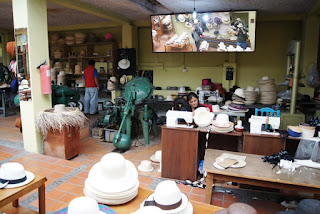
| Panama hats are originally from Ecuador. They are woven in villages surrounding Cuenca and shaped and finished in factories like this in Cuenca. |
 |
| There are also many artesans weaving. I bought an ikat shawl from this weaver. They are woven on a loom that he wears around his body. |
 |
| We went hiking in Cajas National Park, 30 km west of Cuenca. The paramo here holds a lots of small lakes. It was pouring rain, but our hour and half hike was still incredibly beautiful. |
 |
| Street vendors in Vilcabamba. Vilcamba is about 80km from the Peruvian border, hence the two Peruvian ladies selling stuff from Peru. |
 |
| The poster says "Vilcabamba - World Centre for Gerontology Investigations". People are said to live long lives here (over 100 years old). |
 |
| Maybe it's true.... |
Ingapirca
The Incas were only in Ecuador for 70 years before the Spanish savagely destroyed that civilization. While these ruins do not match those in Peru, it is still impressive to observe the masonry and structures and imagine the rituals and day to day life of the people of that time.
 |
| The site also has remains from a Canari village (pre-Inca), probabaly a granary and water reservoirs. |
 |
| The main temple in an elliptical shape was used for observing the sun to determine when to plant and harvest. |
 |
| Note the lower blocks - they are soooo close fitting that you can not even slip a piece of paper between them. Incredible workmanship. |
 |
| On our early morning walk we came across this trout farm between the hills behind the ruins. |
Continuing South - day 2
On Day 2 of our trip we continued south. Unfortunately, we drove in the clouds for most of the way. This makes driving (and being a passenger :) ) a bit nerve-wracking because of limited visibility on the constantly twisting, winding roads. Sometimes we got above the clouds or below the clouds but generally we were in the clouds for most of the journey.
 |
| Waiting for the credit union in Guamote to open. We stopped in this town for gas.
|
 |
| Alausi - just under the clouds. |
 |
| Saturday - market day and soccer in the market square. |
 |
| We needed some bread for our canned tuna lunch. |
 |
| Typical clothing store in small town.
|
Chimborazo
So...on February 1 we headed south on the Pan-American Highway. On the off-chance that we could get a glimpse of Chimborazo, the highest volcano in Ecuador, we took the road less traveled west around the Chimborazo National Park. This was the start of our 2 week adventure exploring Southern Ecuador. Like every other road in Ecuador, each bend reveals a new stunning vista.
Then, suddenly, around the next bend, there it is...in full majesty... Chimborazo!
... Ecuador’s highest mountain, Chimborazo (6,268 meters), is also the farthest point from the center of the earth and closest point to the sun. Even though it is some 2,500 meters shorter than Everest when measured from sea level, Chimborazo’s peak is actually farther from the center of the earth because of the earth’s equatorial bulge.
Just after we had lunch with this incredible backdrop, the clouds rolled in and obscured the view.
The second treat of this drive was spotting Vicunas, a wild cousin to llamas and alpacas. They used to be indigenous to this part of Ecuador but were hunted to extinction. In the 1980's they were re-introduced from Bolivia and Peru and seem to be thriving in the park now.
 |
| 2800 m above sea level, the Andes, as far as the eye can see
|
Then, suddenly, around the next bend, there it is...in full majesty... Chimborazo!
... Ecuador’s highest mountain, Chimborazo (6,268 meters), is also the farthest point from the center of the earth and closest point to the sun. Even though it is some 2,500 meters shorter than Everest when measured from sea level, Chimborazo’s peak is actually farther from the center of the earth because of the earth’s equatorial bulge.
Just after we had lunch with this incredible backdrop, the clouds rolled in and obscured the view.
The second treat of this drive was spotting Vicunas, a wild cousin to llamas and alpacas. They used to be indigenous to this part of Ecuador but were hunted to extinction. In the 1980's they were re-introduced from Bolivia and Peru and seem to be thriving in the park now.
Subscribe to:
Comments (Atom)


